

| MENU |
| |
| |
| |
| |
| |
| |
| |
| |
| |
| |
| |
| |
| |
Zig Zag Hall
The hall, like many others; takes its name from the local surroundings. In this case their was
a small pathway which ran left to right in a zig zag fashion to the river Mersey. The hall is
reputed to have been a large farm owned by Mr William Mann, which was bought in 1881 by a
Mr Sheen who then converted it into a large and plush dwelling. Mr Sheen lived in the house
for a further 8 years and it was from him that we have the name "Sheen Road". In 1889 the
house was sold to his son Richard Steel who lived in the house for a further 21 years, and
after whom "Steel Avenue" is named upon. As happens so often, the house fell into
disrepair with few parties interested in the property, and as such it was demolished in the
early 20th century. early 20th century.
Liscard Mount is also of historical importance owing its name to the large mansion which
sat in the area built in 1834. The house passed down through 3 locally families before it
was sold off and used as a School under the control of St Hillary's. The School ran for a
short time as an all girl educational building but due to the increasing population it was
demolished for road widening in 1921. Some of the still remained including foundations
and dwarf walls which were eventually demolished in 1935 by the Corporation.
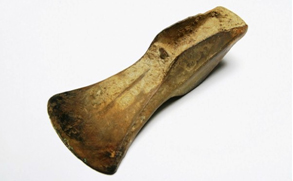
Zig Zag road is also the site of a
Bronze age finding. In 1901 workmen
in the area came across a 3500 year
old axe head which had been used
repeatedly. The middle Bronze age
palstave axe head is kept in glass
display case at the local library which i
will be trying to get a photograph of in
the near future. The palstave axe was
at the leading edge of tool design in
the middle to late Bronze Age thus
making this a great find for the area.
The original settlement of Liscard formed around a steep hill as taken from the translation
of the name "Fort on the Hill". It is belived that the original settlers fo Liscard founded
their homes in what we call today Kirkway. The original settlers of this area were most
likely of Norse or Celtic origin. Records do show that a small settlemnt existed for many
years with only a hand full of dwellings, a small chapel and a Manor House complete with
owner of the lands. There is no photographsic evidence of any of these structures,
including the old windmill which is logged as being demolished in 1832.
Hoseside Road in the village takes its name from the Saxon term of "Hose" meaning sand
hills. For many years a small farm existed in Hoseside Road, named Hoseside Farm. The
farm stood directly opposite Rockland Road and was demolished in the early 1900s.
Another little known fact is that of Broadway Avenue which before becoming a popular
route was formally a small pathway leading to neighbouring Seaview Road called
Townfield Lane. In 1878 an incident took place when a father of two shot himself and his
two sons in the pathway. The path became known locally as suicide lane and as is nearly
always the case, it was shortly after reputed to be haunted. Many residents reported
stories of seeing two children playing in the fields just off the path and then suddenly
disappearing. The murder was confirmed by the authorities and records do exist that
show this actually took place.
Another place worth mentioning is the old quarry off Hoseside Road which was once
depended upon quite heavily for materials. After the quarry Pitt was exhausted it was
turned into a small park by local man Mr Alderman James Smith. The name Captains Pitt,
is somewhat of a sad one and is believed to have come from the tale of a woman who
drowned herself in the Pitt after hearing news that her husband who was a sea captain
had drowned at sea. The couple were believed to have lived in Liscard Castle which was
next door.
Withens Lane was originally known as Old Withensfield Lane after the field which the
lane ran through. The Urmstons were a relatively well known family in Wallasey and at
one time a large house next to Manor Road. The house was built Circa 1735 and being of
such grand stature for the time, was often mistaken for the Manor House. Urmston House
survived for nearly 200 years before being demolished in 1929. Urmstons Road is of
course derived from the family which had a large impact on the village.
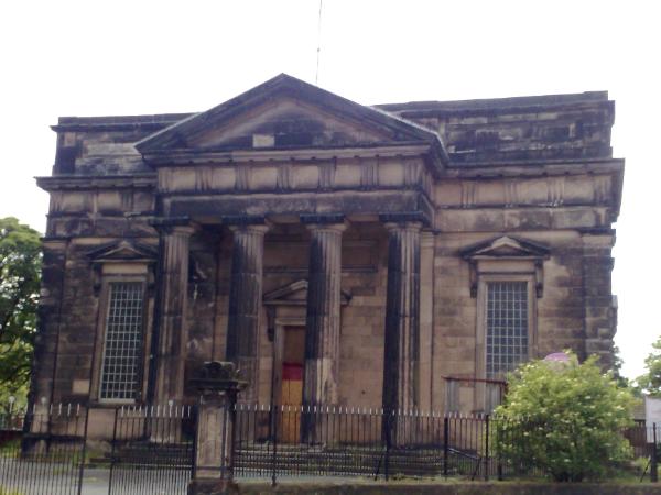
St Johns
Further down the road we find St John standing on Liscard Road with its large stone columns
and Grecian architecture. The church dates back to 1832 when its voluminous rooms would
welcome up to 2000 parishioners at a time. This building clearly stands out from any other
church in Wirral because of its distinct style, and in addition it boats a record of having the
largest unsupported ceiling on the Wirral. The church was erected at the request of Sir John
Tobin and was built from locally quarried materials from the Newlands Drive Quarry.
| | | | | | |