

| MENU |
The following is an article written by local historians John Emmett & Peter France, on the subject of
the lost Roman port of Portus Setantiorum possibly being at Meols:
The lost port of Portus Setantiorum is known to have been located between Anglesey and Morecombe
bay. It is recorded on the maps of Ptolemy and others but the name is written in the area representing
the sea in such a way that the precise location is difficult to determine. The map of Britain discovered by
Charles Bertram under the parsonage of William Stukeley in 1755 actually shows the name pointing
clearly at the tip of the Wirral peninsula. Although this map was denounced as a fake by some historians,
some of the names of the Roman sites, unknown then, have subsequently been found to be correct and it
would be unwise to disregard it today.
In their place names of Roman Britain, Rivett and Smith suggest that the name was first recorded by
Agricola's fleet during a survey of the coats prior to a campaign in the North in 79/80 AD. This was
recorded by Tacitus who also tells us that the fleet was employed to supply and support the land forces. If
Agricola's base was Chester, this fleet must have been based at Meols.
The port was traditionally though to have been located at Fleetwood and this article will examine the case
for both for and against this location. We will also put forward the suggestion that the port was located at
Meols and we are well aware that no firm archaeological evidence exists at present to prove this case in
favour of either site.
Fleetwood
The port of Fleetwood is situated at the tip of the narrow peninsula with the estuary of the River Wyre
forming its eastern side. This small rivers flows northward into Morecombe bay. There is a Roman fort at
Kirkham a few miles to the south and a road is known to have left this fort in the direction of Fleetwood
and to have led to the coast.
Roman finds have been generally few, the main ones being two coin hordes. Watkin in his Roman
Lancashire, mentions a square stone platform being discovered here, possibly the platform for a beacon.
There is no list of finds from the shore comparable to Meols. It would appear that the main reasons for
placing the port at Fleetwood are:
Examining these points it is acknowledged that there are many errors of longitude and latitude in Ptolemy
and that he shows us that what is now Scotland somewhat skewed to the North East which will make a
positive identification of the area unsafe. Indeed Rivett and Smith will not specify a location other than
somewhere on the North West coast of England.
The Setantii have traditionally been though to occupy a relatively small area in Northern Lancashire and
the port is supposed to be under their control, as the name implies. Recent archaeological research in
South Lancashire has produced evidence that their territory did, in fact, extend to the Mersey, which was
known as Setia. The Roman name for Lancashire at the time of writing is thought to be Galacum. Perhaps
the function of the site at Fleetwood was a small port with a signal station to give early warning to the
naval force at Lancashire.
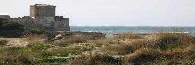
Meols
We must now turn to the site of Meols. It is clear that the large assemble of finds from the coastal erosion
of the area indicates the prolonged use of this place over an extended period of time. The reasons for this
are not difficult to understand.
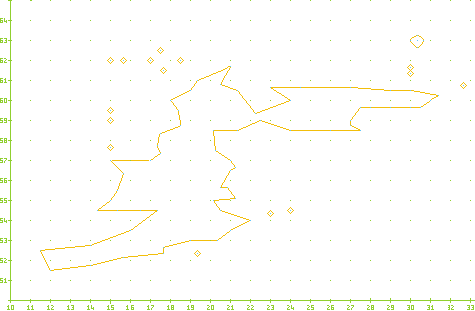
The effect of tidal range in the Roman period, as outlined in the Waddelove paper, helps us to understand
the form and function of the coast, of North Wirral during that period. Here we can imagine the low
promontory of Dove Point on the East with the island of Hilbre to the West. Between these two points lay
the deep and sheltered water of what was later known as the Hoyle Lake. This was protected to the
seaward by Hoyle Bank and must have had the appearance of a lake. It is therefore easily understood
why such a natural asset should be used almost continually over a long period of time.
Despite being overwhelmed by the sea and sand during the Mediaeval period, it was still considered to be
fit for purpose by King William of Orange, and in the mid 19th century it provided a depth of five fathoms
even at low tide.
We are now certain that this side connected to Chester by a direct major road during the Roman period.
The lowest surface of this road has produced evidence contemporary with the foundation of the legionary
fortress, which suggests that the military established themselves at the existing port almost on arrival to
the area. We would suggest that it was at Meols that Agricola based his supply fleet for his campaigns in
the North as this port was close in proximity to his headquarters, and communications need to be reliant
on the wind and tide. The Dee has never favoured Chester as a port for larger vessels and difficult
navigation up the constantly changing channels is well documented.
We have now suggested that Meols was a site of great significance to the Romans. Perhaps it was from
here that Agricola looked out to sea and planned his conquest of Ireland, as described by Tacitus. He had
intended Chester to be the capital of the Provence (Mason), which would be an ideal situation if Ireland
had been absorbed in the empire. The rock channel was the main entrance to the Mersey, the present
channel being improved in 1830, since when the rock channel has been allowed to silt up. We would
suggest that this was the case in the Roman period that the Setia flowed out to the sea at Dove Point. It
is therefore suggested that the main focus of activity was along the promontory, with the Setia on one
side and the Hoyle Lake on the other.
Conclusion
Having considered previous theories and added some of our own, we are now of the opinion, that the site
of Portus Setantiorum lay at the Wirral port of Meols. There are known Roman naval bases at Holyhead
and Lancaster, and Meols lies between them. It is also close to the legionary fortress and is the most
important and practical natural harbour on this section of the British Coast. We are well aware of the lack
of archaeological evidence at either site, but excavations at Meols may just possibly rectify this situation.
It is the only major port noted by Agricola's survey.
the lost Roman port of Portus Setantiorum possibly being at Meols:
The lost port of Portus Setantiorum is known to have been located between Anglesey and Morecombe
bay. It is recorded on the maps of Ptolemy and others but the name is written in the area representing
the sea in such a way that the precise location is difficult to determine. The map of Britain discovered by
Charles Bertram under the parsonage of William Stukeley in 1755 actually shows the name pointing
clearly at the tip of the Wirral peninsula. Although this map was denounced as a fake by some historians,
some of the names of the Roman sites, unknown then, have subsequently been found to be correct and it
would be unwise to disregard it today.
In their place names of Roman Britain, Rivett and Smith suggest that the name was first recorded by
Agricola's fleet during a survey of the coats prior to a campaign in the North in 79/80 AD. This was
recorded by Tacitus who also tells us that the fleet was employed to supply and support the land forces. If
Agricola's base was Chester, this fleet must have been based at Meols.
The port was traditionally though to have been located at Fleetwood and this article will examine the case
for both for and against this location. We will also put forward the suggestion that the port was located at
Meols and we are well aware that no firm archaeological evidence exists at present to prove this case in
favour of either site.
Fleetwood
The port of Fleetwood is situated at the tip of the narrow peninsula with the estuary of the River Wyre
forming its eastern side. This small rivers flows northward into Morecombe bay. There is a Roman fort at
Kirkham a few miles to the south and a road is known to have left this fort in the direction of Fleetwood
and to have led to the coast.
Roman finds have been generally few, the main ones being two coin hordes. Watkin in his Roman
Lancashire, mentions a square stone platform being discovered here, possibly the platform for a beacon.
There is no list of finds from the shore comparable to Meols. It would appear that the main reasons for
placing the port at Fleetwood are:
- The position interpreted from the Ptolemy map
- The Setantii, a sub tribe of Brigantes are known to have occupied the area
- The River Wyre would provide a sheltered harbour for vessels
Examining these points it is acknowledged that there are many errors of longitude and latitude in Ptolemy
and that he shows us that what is now Scotland somewhat skewed to the North East which will make a
positive identification of the area unsafe. Indeed Rivett and Smith will not specify a location other than
somewhere on the North West coast of England.
The Setantii have traditionally been though to occupy a relatively small area in Northern Lancashire and
the port is supposed to be under their control, as the name implies. Recent archaeological research in
South Lancashire has produced evidence that their territory did, in fact, extend to the Mersey, which was
known as Setia. The Roman name for Lancashire at the time of writing is thought to be Galacum. Perhaps
the function of the site at Fleetwood was a small port with a signal station to give early warning to the
naval force at Lancashire.
Meols
We must now turn to the site of Meols. It is clear that the large assemble of finds from the coastal erosion
of the area indicates the prolonged use of this place over an extended period of time. The reasons for this
are not difficult to understand.
The effect of tidal range in the Roman period, as outlined in the Waddelove paper, helps us to understand
the form and function of the coast, of North Wirral during that period. Here we can imagine the low
promontory of Dove Point on the East with the island of Hilbre to the West. Between these two points lay
the deep and sheltered water of what was later known as the Hoyle Lake. This was protected to the
seaward by Hoyle Bank and must have had the appearance of a lake. It is therefore easily understood
why such a natural asset should be used almost continually over a long period of time.
Despite being overwhelmed by the sea and sand during the Mediaeval period, it was still considered to be
fit for purpose by King William of Orange, and in the mid 19th century it provided a depth of five fathoms
even at low tide.
We are now certain that this side connected to Chester by a direct major road during the Roman period.
The lowest surface of this road has produced evidence contemporary with the foundation of the legionary
fortress, which suggests that the military established themselves at the existing port almost on arrival to
the area. We would suggest that it was at Meols that Agricola based his supply fleet for his campaigns in
the North as this port was close in proximity to his headquarters, and communications need to be reliant
on the wind and tide. The Dee has never favoured Chester as a port for larger vessels and difficult
navigation up the constantly changing channels is well documented.
We have now suggested that Meols was a site of great significance to the Romans. Perhaps it was from
here that Agricola looked out to sea and planned his conquest of Ireland, as described by Tacitus. He had
intended Chester to be the capital of the Provence (Mason), which would be an ideal situation if Ireland
had been absorbed in the empire. The rock channel was the main entrance to the Mersey, the present
channel being improved in 1830, since when the rock channel has been allowed to silt up. We would
suggest that this was the case in the Roman period that the Setia flowed out to the sea at Dove Point. It
is therefore suggested that the main focus of activity was along the promontory, with the Setia on one
side and the Hoyle Lake on the other.
Conclusion
Having considered previous theories and added some of our own, we are now of the opinion, that the site
of Portus Setantiorum lay at the Wirral port of Meols. There are known Roman naval bases at Holyhead
and Lancaster, and Meols lies between them. It is also close to the legionary fortress and is the most
important and practical natural harbour on this section of the British Coast. We are well aware of the lack
of archaeological evidence at either site, but excavations at Meols may just possibly rectify this situation.
It is the only major port noted by Agricola's survey.
| |
| |
| |
| |
| |
| |
| |


| Map Comparison |
| Ptolemy's map of Britannia |
| | | | | | |