

| MENU |
Tranmere, a tale of three names....
The word Tranmere derives like many others, from the Norwegian Vikings who settled on the Wirral
peninsula in the 10th century. Tranmere in Old Norse is Trani-melr, roughly translated as sandbank with
the Crane birds. The area of Tranmere originally started out as three separate hamlets which eventually
merged into one. The first was a small fishing village called Hinderton which stood at the banks of the
Mersey, and extended upto the Green Lane area. This area became known locally as Lower Tranmere.
The second village which merged was the original village of Tranmere which was centred around the Holt
or Holt Hill as we know it today. This area was defined as upper Tranmere. The third hamlet was
extremely small and consisted of a few small dwellings around Heathfield Road. This was known as Watts
Heath.
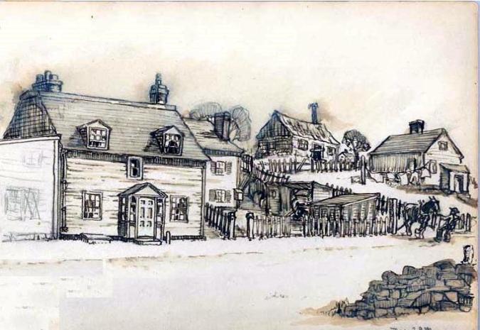
Lower Tranmere, or Hinderton stood between Holt Hill and the river Mersey. The village possessed a
water inlet from the river Mersey known locally as the Tranmere Pool. This is where the Happy Valley
stream entered the river. The river frontage, and a old ferry were all eventually engulfed by the Cammell
Laird's shipyards before 1909. It had been an established fishing village for centuries and until 1936 a row
of fisherman's cottages stood in Green Lane. The area was bisected by the Old Chester Road, which was
built in 1790 as the main highway between Woodside Ferry and Chester by crossing the Tranmere pool
until the construction of Thomas Brassey's New Chester Road; which also had an embankment across the
Tranmere Pool in 1839. Hinderton's second industry was stone quarrying, from which formed a number of
quarries in the face of the hill which were successfully worked until 1909.
Upper Tranmere sprang up around the edge of the ridge overlooking Birkenhead Priory and pool, this
became known as the Holt. Holt hill is said to contained until the early 19th century, a remnant of the
great Wirral forest, as a deed of no later than 1284 refers to the forest of Tranmere as "Yielding wood for
building firewood and pasture and pannage for pigs". The woodland would have been on Holt hill which in
1835 was recorded as "Abounding with the favourite spring flowers and a favourable collecting ground for
mosses and lichens". Holt Hill is one of the oldest roads in the district It is said to have been one of the
first to have been turnpiked, as Greenwoods map of 1818 shows a toll bar close to the bottom of the hill.
Incidentally Holt hill is also recorded as Wirral steepest Road. The Old Hall and its surrounding estate, was
situated in upper Tranmere on the brow of the hill around Church Road. It is said to have been built to
encompass the great views across the local area and look directly out over the river Mersey.
In 1801 the Tranmere area had a recorded population of 353, mainly centred around Church Road and the
nearby hamlet of Hinderton. The area comprised of six large working farms, and many large private
dwellings. There was also a stone pinfold which was an area where stray animals were rounded up if their
owners failed to properly supervise their use of common grazing land. A fine had to be paid for their
release, it is also likely that it was used by drovers taking their stock to market. The pinfold was
demolished in 1935. The area also had , a small brewery, now part of a local dwelling; of which the cellar
is still in existence. The village had three ale houses, two shops, around seventy small cottages and an
ancient village cross where locals would meet for work. The Tithe map of Tranmere in 1843 also records a
shop called Swans, which stood at 90 Church Street, and a shop called Reed's in Walker Place. This is
believed to be named after Mr. W. Walker, who owned the quarry. There is also many housing
developments also owned by Mr W.Walker, built on in 1870 for detached houses, first known as Shewell's
Road (presumably after the Rev Shewell of local renown) and then Chestnut Grove. The village had also
began working with stone excavation by this time, and two quarry were already in use; a further two were
created a short time after. Further notes from the period detail that there was an old farm house and
associated outbuildings with bricked up mullioned windows of some worth. There was also an inn called
the Black Horse with a date plate of 1757 which appears to have been a former coach house. The other
public house is recorded as the Sportsman's arms which at the time is noted as having a fine thatched
roof.
By 1901, the three villages had merged and the number of residents had swelled to a bursting 37,709
making the new Tranmere the second most populous settlement in Wirral, second only to the vast area of
Neston. The present day Tranmere is covered in late Victorian terraced housing with much of the original
Tranmere Pool area now covered by industrial works such as the boat yard. A few remnants of the old
village still survive, such as the old Tranmere Cross in Victoria park and the odd landmark; but on the
whole the village life it once knew has been overrun by the Bustling area of a town populous.
The word Tranmere derives like many others, from the Norwegian Vikings who settled on the Wirral
peninsula in the 10th century. Tranmere in Old Norse is Trani-melr, roughly translated as sandbank with
the Crane birds. The area of Tranmere originally started out as three separate hamlets which eventually
merged into one. The first was a small fishing village called Hinderton which stood at the banks of the
Mersey, and extended upto the Green Lane area. This area became known locally as Lower Tranmere.
The second village which merged was the original village of Tranmere which was centred around the Holt
or Holt Hill as we know it today. This area was defined as upper Tranmere. The third hamlet was
extremely small and consisted of a few small dwellings around Heathfield Road. This was known as Watts
Heath.
Lower Tranmere, or Hinderton stood between Holt Hill and the river Mersey. The village possessed a
water inlet from the river Mersey known locally as the Tranmere Pool. This is where the Happy Valley
stream entered the river. The river frontage, and a old ferry were all eventually engulfed by the Cammell
Laird's shipyards before 1909. It had been an established fishing village for centuries and until 1936 a row
of fisherman's cottages stood in Green Lane. The area was bisected by the Old Chester Road, which was
built in 1790 as the main highway between Woodside Ferry and Chester by crossing the Tranmere pool
until the construction of Thomas Brassey's New Chester Road; which also had an embankment across the
Tranmere Pool in 1839. Hinderton's second industry was stone quarrying, from which formed a number of
quarries in the face of the hill which were successfully worked until 1909.
Upper Tranmere sprang up around the edge of the ridge overlooking Birkenhead Priory and pool, this
became known as the Holt. Holt hill is said to contained until the early 19th century, a remnant of the
great Wirral forest, as a deed of no later than 1284 refers to the forest of Tranmere as "Yielding wood for
building firewood and pasture and pannage for pigs". The woodland would have been on Holt hill which in
1835 was recorded as "Abounding with the favourite spring flowers and a favourable collecting ground for
mosses and lichens". Holt Hill is one of the oldest roads in the district It is said to have been one of the
first to have been turnpiked, as Greenwoods map of 1818 shows a toll bar close to the bottom of the hill.
Incidentally Holt hill is also recorded as Wirral steepest Road. The Old Hall and its surrounding estate, was
situated in upper Tranmere on the brow of the hill around Church Road. It is said to have been built to
encompass the great views across the local area and look directly out over the river Mersey.
In 1801 the Tranmere area had a recorded population of 353, mainly centred around Church Road and the
nearby hamlet of Hinderton. The area comprised of six large working farms, and many large private
dwellings. There was also a stone pinfold which was an area where stray animals were rounded up if their
owners failed to properly supervise their use of common grazing land. A fine had to be paid for their
release, it is also likely that it was used by drovers taking their stock to market. The pinfold was
demolished in 1935. The area also had , a small brewery, now part of a local dwelling; of which the cellar
is still in existence. The village had three ale houses, two shops, around seventy small cottages and an
ancient village cross where locals would meet for work. The Tithe map of Tranmere in 1843 also records a
shop called Swans, which stood at 90 Church Street, and a shop called Reed's in Walker Place. This is
believed to be named after Mr. W. Walker, who owned the quarry. There is also many housing
developments also owned by Mr W.Walker, built on in 1870 for detached houses, first known as Shewell's
Road (presumably after the Rev Shewell of local renown) and then Chestnut Grove. The village had also
began working with stone excavation by this time, and two quarry were already in use; a further two were
created a short time after. Further notes from the period detail that there was an old farm house and
associated outbuildings with bricked up mullioned windows of some worth. There was also an inn called
the Black Horse with a date plate of 1757 which appears to have been a former coach house. The other
public house is recorded as the Sportsman's arms which at the time is noted as having a fine thatched
roof.
By 1901, the three villages had merged and the number of residents had swelled to a bursting 37,709
making the new Tranmere the second most populous settlement in Wirral, second only to the vast area of
Neston. The present day Tranmere is covered in late Victorian terraced housing with much of the original
Tranmere Pool area now covered by industrial works such as the boat yard. A few remnants of the old
village still survive, such as the old Tranmere Cross in Victoria park and the odd landmark; but on the
whole the village life it once knew has been overrun by the Bustling area of a town populous.

| |
| |
| |
| |
| |
| |
| |
| |
| | | | | | |